A new report from Moody’s Insurance Solutions highlights that meteorological agencies and groups have reached a strong consensus predicting an above-average 2024 North Atlantic hurricane season, with some forecasters not ruling out a hyperactive season.
June 1 marked the official start of the 2024 North Atlantic hurricane season. Moody’s RMS Event Response issued an executive summary of its 2024 Northern Hemisphere Tropical Cyclone Outlook report, reviewing North Atlantic and Western North Pacific seasonal forecasts and examining key oceanic and meteorological drivers.
The US National Oceanic and Atmospheric Administration (NOAA) forecasts 17 to 25 named storms, with eight to 13 expected to become hurricanes, and four to seven becoming major hurricanes (Category 3 or stronger). The Accumulated Cyclone Energy (ACE) index, measuring the overall duration and intensity of storms, is projected to range between 145 and 237.
These predicted storm activity ranges are above NOAA’s 1991–2020 U.S. Climate Normals seasonal average of 14 named storms, seven hurricanes, and three major hurricanes. The 1951–2020 median ACE index value is 96.7.
Other meteorological forecast agencies, including Colorado State University, Tropical Storm Risk, the UK Met Office, the European Centre for Medium-Range Weather Forecasts, and Mexico’s Servicio Meteorológico Nacional, have issued outlooks in line with NOAA’s guidance, suggesting an above-average season with the possibility of a hyperactive season.
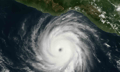
Historically, tropical cyclone activity in the North Atlantic Basin peaks between mid-August and late October. Many forecast groups will release revised forecasts in early August to reflect increased certainty in meteorological and oceanic variables.
The forecasts are influenced by several key seasonal oceanic and atmospheric factors, primarily North Atlantic sea surface temperatures (SSTs) and the El Niño-Southern Oscillation (ENSO). Much of the uncertainty in seasonal hurricane activity forecasts arises from uncertainty about the ENSO phase during the peak hurricane months of August, September, and October. As of June, ENSO-neutral conditions are present in the Pacific Ocean.
Probabilistic forecasts from the Climate Prediction Center indicate a 77% chance of La Niña conditions during the peak hurricane months and a greater than 80% chance of these conditions persisting into the Northern Hemisphere winter. La Niña typically leads to weaker upper-level westerly winds and weaker lower-level easterly trade winds across the North Atlantic Basin, reducing vertical wind shear and increasing atmospheric instability, which encourages hurricane formation, development, and intensification.
Without other influencing factors, activity would be expected to be above normal. The forecast emergence of La Niña conditions is supported by a forecast weakening of vertical wind shear anomalies and weaker-than-normal trade winds, both facilitating tropical activity.
Warmer SSTs enhance tropical cyclone activity by providing increased energy and moisture. SSTs in the main development region of the tropical North Atlantic are near record highs for this time of year, with an area-averaged temperature anomaly of approximately +1.22° Celsius. Many areas are forecast to experience anomalies of +0.55° Celsius to +1.05° Celsius between August and October 2024, covering the peak hurricane months.
These warmer temperatures suggest that the Atlantic Multidecadal Oscillation (AMO) and Atlantic Multidecadal Variability (AMV) are currently in a positive (warm) phase, typically enhancing tropical activity by providing increased energy and moisture.
The combined influence of these factors has resulted in the forecast for an above-average season in 2024. Other factors, such as the North Atlantic Oscillation (NAO), the Madden-Julian Oscillation (MJO), and the Saharan Air Layer (SAL), can influence tropical cyclone activity on a weekly or monthly basis but are challenging to forecast at seasonal timescales.
In the Western North Pacific, forecasts indicate a slightly below-average to near-average year in 2024. La Niña conditions and the associated anomalous Walker circulation typically result in stronger easterly trade winds, increasing vertical wind shear, and decreasing atmospheric instability, often leading to a less active year.
La Niña years also see the Southeast Asia monsoon trough retreat westward and the subtropical ridge strengthen, shifting the main cyclogenesis region toward the Philippines and the South China Sea.
Sea surface temperatures across the Western North Pacific Basin are expected to be above average between July and November 2024, enhancing tropical activity by providing increased energy and moisture.
The Pacific Decadal Oscillation (PDO), a long-lived ENSO-like climate variability pattern, has been in a negative phase since around 2020, meaning activity has generally decreased compared to the average. This phase is expected to continue through 2024.
What are your thoughts on this story? Please feel free to share your comments below.