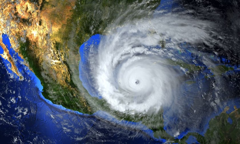
The 2025 Atlantic hurricane season arrives amid a puzzling contradiction: long-standing climate signals suggest a potentially slower start to tropical storm activity, yet official forecasts point decisively toward an above-normal season. This tension has captured the attention of insurers and reinsurers alike, for whom the frequency, intensity, and unpredictability of tropical systems carry direct consequences for pricing, exposure modeling, and catastrophe response planning.
Data from the National Oceanic and Atmospheric Administration (NOAA) released in late May forecasts a 60% chance of an above-average hurricane season, with 13 to 19 named storms expected, including 6 to 10 hurricanes and as many as five major hurricanes. The underlying drivers? Warmer-than-average Atlantic sea surface temperatures, favorable wind patterns, and a potentially more active West African monsoon.
Yet early-season observations present a different story.
Despite record-breaking warmth in subtropical oceans across the Atlantic, Pacific, and Indian basins, the season's first Northern Hemisphere hurricane only formed in the eastern Pacific last week - its latest debut in over three decades. The western Pacific and northern Indian Oceans, typically active by midyear, have been notably quiet.
What’s behind the paradox? Experts point to a complex interplay between ocean temperature gradients and atmospheric conditions. Subtropical ocean waters averaged 73.4 degrees Fahrenheit this May—a new high—while the tropical Atlantic has cooled modestly since last year’s record warmth. This flattening of the temperature differential, or gradient, between the tropics and subtropics results in a more stable atmosphere, less conducive to cyclonic formation.
One emerging wildcard is the development of an “Atlantic Niña” - a cooling trend in the eastern equatorial Atlantic akin to La Niña in the Pacific. While not yet fully established, the early indicators suggest it could play a suppressive role in storm development by altering convection patterns over West Africa, the source region for many long-traveling Cape Verde hurricanes. Historical analysis shows that Atlantic Niñas tend to coincide with quieter Atlantic hurricane seasons.
Still, no-one in the risk business is taking this as a cue to relax.
“Despite recent quiet periods and a slow start, hurricane risks remain elevated,” said NOAA’s acting administrator Laura Grimm. “Coastal and inland areas alike need to stay vigilant.”
The insurance sector is already responding. Enhanced models and decision-support tools, including NOAA’s upgraded Hurricane Analysis and Forecast System, are helping carriers anticipate landfall zones with greater precision. This year, the agency is also offering earlier advisories - up to 72 hours in advance - for potential storm surge impacts, expanding preparation windows for emergency managers and insurers.
Last year’s destructive season, which tallied 18 named storms and two Category 5 hurricanes, serves as a stark reminder that seasonal totals can mask deadly volatility. The 2024 season saw catastrophic flooding from storms like Hurricane Helene and Hurricane Milton, with losses placing it among the top three costliest on record.
For insurance firms, the focus this year is twofold: recalibrating near-term exposure based on shifting ocean patterns, and preparing for what could be a highly volatile peak season, even if the opening act seems deceptively mild.
With both NOAA and independent climate researchers stressing the growing intensity - and not just the frequency - of hurricanes in a warming climate, the industry is left to navigate a landscape of heightened uncertainty. For actuaries, catastrophe modelers, and claims managers, that means planning for extremes, not averages.
While a weak start may hint at a quieter June, history - and recent memory - reminds us that all it takes is one landfalling hurricane to upend the year.